Latest Post | Last 10 Posts | Archives
Previous Post: Rauner claims Arduin contract will “save us billions”
Next Post: This just in… Rauner issues executive order allowing employees to stop paying “fair share” dues - Dues to be placed in escrow - 6500 workers impacted - Raw audio - AFSCME responds: “Blatantly illegal abuse of power” - Cullerton responds
Posted in:
* From a reader…
Hi, Rich.
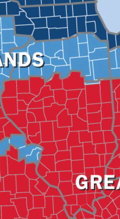
I stumbled into this interesting map that might make for a good blog item. It splits up North America based on political culture and its historic development. Note that Illinois is one of only a handful of states that is divided into three “nations.” When I give my standard “how-things-work-in-Springfield” talk to civic groups or students, I often argue that regional differences shape the debate in Illinois as much as partisan affiliation does. This gives a pretty good overview of that phenomenon:
* Here’s a close-up shot of Illinois. The full map is here. Dark blue is “Yankeedom,” light blue is “The Midlands” and the red area is “Greater Appalachia”…
* The categories are explained…
YANKEEDOM. Founded on the shores of Massachusetts Bay by radical Calvinists as a new Zion, Yankeedom has, since the outset, put great emphasis on perfecting earthly civilization through social engineering, denial of self for the common good, and assimilation of outsiders. It has prized education, intellectual achievement, communal empowerment, and broad citizen participation in politics and government, the latter seen as the public’s shield against the machinations of grasping aristocrats and other would-be tyrants. Since the early Puritans, it has been more comfortable with government regulation and public-sector social projects than many of the other nations, who regard the Yankee utopian streak with trepidation.
THE MIDLANDS. America’s great swing region was founded by English Quakers, who believed in humans’ inherent goodness and welcomed people of many nations and creeds to their utopian colonies like Pennsylvania on the shores of Delaware Bay. Pluralistic and organized around the middle class, the Midlands spawned the culture of Middle America and the Heartland, where ethnic and ideological purity have never been a priority, government has been seen as an unwelcome intrusion, and political opinion has been moderate. An ethnic mosaic from the start—it had a German, rather than British, majority at the time of the Revolution—it shares the Yankee belief that society should be organized to benefit ordinary people, though it rejects top-down government intervention.
GREATER APPALACHIA. Founded in the early eighteenth century by wave upon wave of settlers from the war-ravaged borderlands of Northern Ireland, northern England, and the Scottish lowlands, Appalachia has been lampooned by writers and screenwriters as the home of hillbillies and rednecks. It transplanted a culture formed in a state of near constant danger and upheaval, characterized by a warrior ethic and a commitment to personal sovereignty and individual liberty. Intensely suspicious of lowland aristocrats and Yankee social engineers alike, Greater Appalachia has shifted alliances depending on who appeared to be the greatest threat to their freedom. It was with the Union in the Civil War. Since Reconstruction, and especially since the upheavals of the 1960s, it has joined with Deep South to counter federal overrides of local preference.
* The Question: Do you agree or disagree with your locale’s description? Take the poll and then explain your answer in comments, please.
posted by Rich Miller
Monday, Feb 9, 15 @ 2:16 pm
Sorry, comments are closed at this time.
Previous Post: Rauner claims Arduin contract will “save us billions”
Next Post: This just in… Rauner issues executive order allowing employees to stop paying “fair share” dues - Dues to be placed in escrow - 6500 workers impacted - Raw audio - AFSCME responds: “Blatantly illegal abuse of power” - Cullerton responds
WordPress Mobile Edition available at alexking.org.
powered by WordPress.
Mostly agree. I’m pretty sure I heard Jack Van Der Slik lay that down about 30 years ago at old SSU. Made sense then, more so now.
Comment by Wordslinger Monday, Feb 9, 15 @ 2:23 pm
=== I heard Jack Van Der Slik lay that down about 30 years ago===
Same here. I think we took that class together.
Comment by Rich Miller Monday, Feb 9, 15 @ 2:24 pm
Mostly agree, although I’d say alot of folks in Northern Illinois(excluding Chicago) behave more like Appalachia folks than good ol’ yanks.
Comment by Rockford's Finest Monday, Feb 9, 15 @ 2:25 pm
There appears to be much ‘logic’ in this map. But personally, I do not think of Cook County as being Yankeedom. Not exactly certain what it is but not that.
Comment by Federalist Monday, Feb 9, 15 @ 2:26 pm
Mostly agree. I would include Livingston County in Appalachia after working there for 20 years. Not much difference between Livingston and McLean counties minus the university liberals.
Comment by Nearly Normal Monday, Feb 9, 15 @ 2:29 pm
Mostly agree. Find it curious Peoria County is “The Midlands” and Tazewell County is “Greater Appalachia”
Comment by Anyone Remember Monday, Feb 9, 15 @ 2:30 pm
Mostly agree. Experienced a bit of culture shock when I started dating my wife with her accent.
Comment by Norseman Monday, Feb 9, 15 @ 2:30 pm
@Anyone Remember
The fine people of Goofy Ridge would surely be offended if they were able to read your comment.
Comment by Ducky LaMoore Monday, Feb 9, 15 @ 2:31 pm
I mostly agree, but feel that Appalachia is a bit too far north. I’d probably push it to between I-72 and I-70.
As an aside, when I had a temporary teaching gig at SIU/C in the late 80’s, I had a grad assistant with a very pronounced southern accent. I asked where he was from and when he told me Benton, I asked “Kentucky?” He sounded like my relatives from that state. He replied, “Illinois.”
Comment by G'Kar Monday, Feb 9, 15 @ 2:32 pm
Sort of, as a Chicagoian, I remind my wife who is from Springfield that the south starts at Kankakee and the deep south starts at Bloomington…
Comment by OneMan Monday, Feb 9, 15 @ 2:33 pm
Also live in Yankeeland as it were by about a block…
Comment by OneMan Monday, Feb 9, 15 @ 2:34 pm
Voted “mostly agree”
As a layman out here in Kendall County, it makes mostly sense in talking and getting to know people and their families with multiple generational roots here.
I really woukd like to read more about this topic, and I need to make time to learn more. I have family roots, like many I am sure, that straddle more than one of these categories and maybe learning more about these groups, I’ll learn more about myself and my family origins too.
Interesting question and topic.
Comment by Oswego Willy Monday, Feb 9, 15 @ 2:35 pm
Having lived in Decatur for 10 years, then BloNo area for 10 years, I’d move the Midlands down to include McLean County.
Comment by Rayne of Terror Monday, Feb 9, 15 @ 2:36 pm
===I’d probably push it to between I-72 and I-70===
I’ve always thought that 72 was our unofficial Mason/Dixon line here.
Comment by Rich Miller Monday, Feb 9, 15 @ 2:39 pm
I highly recommended the entire book:
http://www.colinwoodard.com/americannations.html
Comment by Bill White Monday, Feb 9, 15 @ 2:40 pm
- Bill White -,
Thanks. I’ll give it a look.
Comment by Oswego Willy Monday, Feb 9, 15 @ 2:44 pm
I studied the same thing 30 years ago in an anthropology class. The book then was The Nine Nations of North America.
Comment by Cheryl44 Monday, Feb 9, 15 @ 2:50 pm
Woodard amplifies and to some extent corrects “Albion’s Seed”
Also, what I believe Woodard’s book has overlooked are two significant 20th century migrations: rural blacks from the Deep South (LA, MS, AL) coming to northern cities (often riding the Illinois Central to Chicago) and the Appalachian migration from WV & KY to factory towns before, during and just after WW2.
Prior to those migrations, the color bands in the image Rich posted were probably quite accurate.
But when there are folks in McHenry County Illinois (or Wisconsin and Michigan) slapping Confederate flag bumper stickers on their cars, times have changed.
Comment by Bill White Monday, Feb 9, 15 @ 2:50 pm
Mostly disagree- think the bottom two are too far north- G’Kar hit it about right for the lower line. Central Illinois certainly isn’t Appalachia.
Comment by downstate commissioner Monday, Feb 9, 15 @ 2:53 pm
Disagree with the apparent inclusion of St. Louis in the Midlands. The city has a distinctly Southern flavor to it, much more so than Springfield. I sense a crossing of regions immediately after crossing from St. Louis to the Illinois side of the border. Union/Confederacy distinctions remain strong.
Comment by Quiet Sage Monday, Feb 9, 15 @ 2:53 pm
I really meant to say, “former free state/former slave state distinctions remain strong.” Missouri, of course, was divided between Union and Confederate governments, with St. Louis under Union control.
Comment by Quiet Sage Monday, Feb 9, 15 @ 2:56 pm
In my experience growing up there, I think Will County is more similar to the Greater Appalachia category.
Comment by distracted Monday, Feb 9, 15 @ 2:56 pm
There’s more about that map that works than doesn’t. I too would push the line closer to I-72 than I-74.
Comment by AC Monday, Feb 9, 15 @ 2:56 pm
“Somewhat disagree”. West of Huntley and DeKalb is definitely more Midlands. Extending the map, do you think all of Wisconsin is ‘Yankeedom’?
Comment by Bogey Golfer Monday, Feb 9, 15 @ 3:02 pm
Disagree- anyone who says we in Yankeedom prize “denial of self” clearly hasn’t spent many late nights at Berlin at Sheffield and Belmont.
Or, for that matter, The Mutiny at Western and Fullerton. We party way too hard to be accused of self-denial.
Comment by tikkunolam Monday, Feb 9, 15 @ 3:03 pm
Champaign County is in “greater Appalachia?” I’d think maybe more like the Midlands.
Comment by wayward Monday, Feb 9, 15 @ 3:04 pm
The larger map is missing several county wide reservations that should be included with first nations.
Comment by AC Monday, Feb 9, 15 @ 3:05 pm
Have lived in McLean, Tazewell, and Macon counties.
Agree with Rich that I-72 is a decent Illinois Mason-Dixon Line.
No way that Tazewell or McLean should be Greater Appalachia, instead of The Midlands. Too many conservatives of German and UK ancestry.
I can certainly tell the cultural differences in Macon County, compared to the other 2. Even more noticeable south of I-70.
Comment by BobInIllinois Monday, Feb 9, 15 @ 3:06 pm
Mostly agree. I think the red/light blue boundary should be a little more southern as I am from and live in the top part of the red and don’t find it to be as Appalachian based upon all my relatives in Egypt. I think it is more Midland based upon my relatives just north of the line.
Comment by D.P.Gumby Monday, Feb 9, 15 @ 3:08 pm
I’m trying to figure out how the North Shore fits into this picture.
Comment by Wensicia Monday, Feb 9, 15 @ 3:09 pm
=== Central Illinois certainly isn’t Appalachia ==
Have you been to Pike, Brown or Adams counties lately?
Comment by The Unknown Poster Monday, Feb 9, 15 @ 3:10 pm
Not sure I agree with St Louis area in “Midlands.” That area in Mo. still feels mostly Southern to this Southern Illinois native.
Comment by vise77 Monday, Feb 9, 15 @ 3:10 pm
I live in the northwest suburbs of Cook. There are some pretty big pockets of red here and in Dupage county.
Comment by No Longer A Lurker Monday, Feb 9, 15 @ 3:12 pm
The migratory patterns have linguistic evidence that remains today 100 years or more from the start of the movement of people. Drawing the lines of those descendants is not difficult.
Time has perhaps allowed the mix of culture and education affect political attitudes. In all it sounds interesting.
Comment by SkeptiCal Monday, Feb 9, 15 @ 3:14 pm
Champaign/Urbana has a much more Midlands/Northern feel than Springfield or Decatur. Bloomington/Normal is a definitively Midlands/Northern city. I would place the border latitude between Midlands and Appalachia somewhere between Lincoln and Bloomington.
Comment by Quiet Sage Monday, Feb 9, 15 @ 3:15 pm
I think this stuff is dynamite, and is pretty close to my experiences living in various places. Nate Silver once posted — and it may have been in 2008, before he was really famous — a breakdown on every state and which other states were most similar electorally. Something along the line of “Ohio’s voting record is just really a combination of 50% Pennsylvania, 20% Missouri, and 30% Indiana.” It’s findings were along the lines of this map, but it also accounted for things like relative electoral strengths and characteristics of a state’s major metropolitan areas, etc. I wish I could find it, but google just won’t cooperate.
Comment by Sam Weinberg Monday, Feb 9, 15 @ 3:21 pm
Yankeedom=It has prized education, intellectual achievement, communal empowerment, and broad citizen participation in politics and government, the latter seen as the public’s shield against the machinations of grasping aristocrats and other would-be tyrants.=
Funny thing, Chicago has for many decades been run by “the machinations of grasping aristocrats and would-be tyrants”, like the “Daley”, “Madigan”, “Mell” and “Stroger” aristocracies. “Self Denial” ? Pullleeeeeeezzzzz! Seems like a liberal who can oonly see out of his left eye came up withy this….
Comment by Arizona Bob Monday, Feb 9, 15 @ 3:24 pm
I grew up in a homogenous little Eastern European community in deep Southern Illinois. I don’t think I met a Protestant or heard a Southern accent until I got to high school. Not that we were Trotskyites or anything down there in coal country. But there are ripples and pockets in this map.
Comment by anonymous Monday, Feb 9, 15 @ 3:26 pm
As someone who would feel probably much more comfortable living in Yankeedom or even in part of the Midlands, but who lives deep in Greater Appalachia, I have to mostly agree.
I am not certain however that the boundary lines are as accurate as they could be.
Thank you Bill White - I am intrigued and will read the entire book.
Comment by illini Monday, Feb 9, 15 @ 3:39 pm
Somewhat disagree. The demographics have changed so much in the last 40 years the map would have to be substantially revised.
Comment by DuPage Monday, Feb 9, 15 @ 3:40 pm
Point to ponder - if extended due west, the Mason Dixon line runs through Springfield, basically UIS’ southern boundary. Which means Speaker Madigan’s fund raisers at the Island Bay Yacht Club are held in the “South” … .
Comment by Anyone Remember Monday, Feb 9, 15 @ 3:43 pm
Mostly agree.
Illinois was first settled by people traveling down the Ohio River and then up the Mississippi and Illinois Rivers. Those early settlers were from Appalachia and brought their individual freedom philosophy.
Later Chicago grew with waves of immigration. Many of those people came from Europe and they brought a different political philosophy.
Of course today the state is populated by people from all over with a variety of politics. But the original philosophies still have influence.
Comment by Sir Reel Monday, Feb 9, 15 @ 3:54 pm
Somewhat disagree. This probably made more sense in the 1800’s, before people migrated in airplanes. A better, more definitive distinction is that of dialects. Dialects or accents breakdown not just the state but the City. See Tongue Ties by Timothy C. Frazer, the linguistic map of western Illinois, www.lib.niu.edu/2007/ih070512.html
Comment by Keyser Soze Monday, Feb 9, 15 @ 3:56 pm
—Having lived in Decatur for 10 years, then BloNo area for 10 years, I’d move the Midlands down to include McLean County.
Having grown up in Normal, I’d say it’s right actually. A lot of the initial immigrants came from Appalachia or the south in the form of Scottish immigrants and while it’s more suburban now, it’s still has a deep distrust of federal government.
That said, any idiot flying a confederate flag in McLean County to be hit on the head before being sent to remedial history.
Comment by ArchPundit Monday, Feb 9, 15 @ 4:01 pm
Fascinating. Pretty sure these days Champaign or Vermilion or McLean Counties don’t belong in Greater Appalacia, though.
Comment by Responsa Monday, Feb 9, 15 @ 4:04 pm
disagree with the characterizations of my family heritage, shown in all three regions, so hard to take the humor because of all the errors.
Comment by Amalia Monday, Feb 9, 15 @ 4:07 pm
This is generally accurate but in reality, the map should be much more mosaic. There are many counties in Wisconsin for example that most definitely would not tie in with Yankeedom.
I wonder if someone has updated this in recent years?
Comment by Jake From Elwood Monday, Feb 9, 15 @ 4:12 pm
The basis of the map is Colin Woodard’s book, “American Nations: A History of the Eleven Rival Regional Cultures of North America.”
It’s an excellent book. Michael Barone has made similar references in his works. He usually refers to the Great Appalachia as the Jacksonian Belt.
Comment by Downstate Illinois Monday, Feb 9, 15 @ 4:17 pm
To this Southern Illinoisan, anything north of I-64 to about I-74 seems like the midlands. The rest is Yankeedom.
Comment by Deep South Monday, Feb 9, 15 @ 4:21 pm
I somewhat agree. DuPage County, Some Kane and some Lake Co. excepted though.
Comment by A guy Monday, Feb 9, 15 @ 4:42 pm
I mostly disagree. Sure, we have several distinct political and historical cultures in the U.S. and there are strong regional differences in those. But maps like this tend to be gross simplifications. The fact is, since WWI, the U.S. population has been highly mobile, and it’s been far too mobile for a map like this to convey.
Comment by 47th Ward Monday, Feb 9, 15 @ 5:10 pm
Still mostly agree, although someone pointed out the Great Migration after the ‘27 Flood. That was huge and mostly focused in Yankeedo. (surprise).
I’d add that in the 1920s blacks and immigrant Catholic Italians, Irish and Poles tuned up the Klan and Mr. Peabodys goons pretty good down in Little Egypt. They still uncover a burial plot every now and then around Herrin.
I’m sure those that came before us would just whistle zipiitydodah out of their tukkus about the good ole days before unions, minimum wage, prevailing wage, etc.
Comment by Wordslinger Monday, Feb 9, 15 @ 5:47 pm
Chicago here—agree with my part of the map. It’s so interesting to meet people from the more southern areas and realize some pretty major differences in culture, religion, upbringing, influences, etc.
Comment by Belle Monday, Feb 9, 15 @ 5:59 pm
I’ve lived in Peoria and Bloomington and largely agree. McLean and Tazewell have much more of a Fundamentalist, reactionary ethic than Peoria.
Comment by Independent Monday, Feb 9, 15 @ 6:04 pm
It is absolutely accurate, and Illinois has always been divided on these lines. Remember, northern Illinois got its settlers from New England and the Quaker country of Pennsylvania through land grants to Revolutionary War and War of 1812 veterans. The southern half of Illinois was settled almost entirely by settlers moving up from the South (Lincoln, for instance). The cultural divide has been with us ever since and was very pronounced in the Civil War years because southern Illinois people were culturally southerners themselves and were closely tied to the south economically as well. Remember, right after Ft. Sumter Gov. Yates sent trusted Republican troops from the Chicago area to southern Illinois to seize strategic points such as Cairo before southern Illinois Confederate sympathizers took control of the area. There is a great display on this cultural divide at the Illinois State Museum.
Comment by Skirmisher Monday, Feb 9, 15 @ 6:41 pm
the question? Can’t we all just get along?better?
Comment by flea Monday, Feb 9, 15 @ 7:18 pm
Maybe there could be some islands of light blue downstate. Otherwise accurate. I’d say that red needs to be moved up to the Kankakee-Iroquois County line though. There’s quite a difference once you move past that line until you get to Champaign
Comment by K3 Monday, Feb 9, 15 @ 7:41 pm
I disagree.
We have moved on from stereotypes in our digital world. We can know voters based their age, home values, voluntary organizations, employment, and previous voter history.
Geographical stereotypes come from a geographical focus. Our Constitution empowers the Senate based on geography. So it is natural to begin seeing voters in a similar way. That is an increasingly obsolete way of thinking.
When we use stereotypes we get lazy and we stop listening and thinking about voter motivation and campaigns. Fact is, voters don’t base their votes upon their zip code.
We shouldn’t see them this way anymore either.
Comment by VanillaMan Monday, Feb 9, 15 @ 10:21 pm
I somewhat agree with this, especially in the description of greater Appalachia. It reminds me of Jim Webb’s book “Born Fighting: How the Scots-Irish Shaped America”
Comment by NW Suburbs Joe Tuesday, Feb 10, 15 @ 8:35 am
“The fact is, since WWI, the U.S. population has been highly mobile, and it’s been far too mobile for a map like this to convey.”
Sure, but culture tends to persist in the wake of people moving, often for more than a generation.
Comment by vise77 Tuesday, Feb 10, 15 @ 8:56 am
I think Daniel Elazar did it better when he defined the Individualistic, Moralistic and Traditionalistic political cultures. Around the middle of the last century, IL had each culture in about a third of the state. Individualistic described Chicago machine pols. Moralistic culture reigned in most of Downstate, while way down south the Traditionalistic culture was similar to that in the Southern states.
Comment by Bemac Tuesday, Feb 10, 15 @ 9:27 pm